Omus’s Weblog

Politics, Trekking, Environment & Personal

KUTCH trip- 11-14th Jan 2020 January 20, 2020

The saying goes “KUTCH Nahin dekha, to KUCH nahin dekha”.  The English translation is: If you have not seen Kutch, you have not seen anything. And it’s very much TRUE.

The area is indeed a unique geography & add over it, the masala of colorful culture. The presence of military to guard one of the most tensed & harsh international borders of the world, gives it a bigger ah! & Oooh! Factor. Also, it is one of few successful govt. sponsored & developed tourism site. I guess one of the many factors, people voted Mr. Narendra Modi so many times, despite all the criticism of his policies & decisions.

Rann of Kutch Geography:

  • Western part of India, in state of Gujarat.
  • It’s hot, marshy & salty land spread over 1000s of Sq.km.
  • Winters (November- February) are best time to visit it.
  • In Summers, it can be “Valley of Death”.
Tour Map

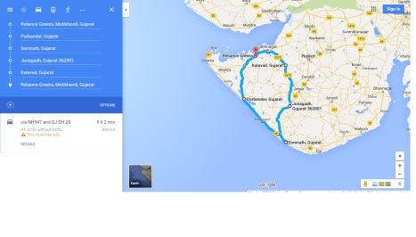
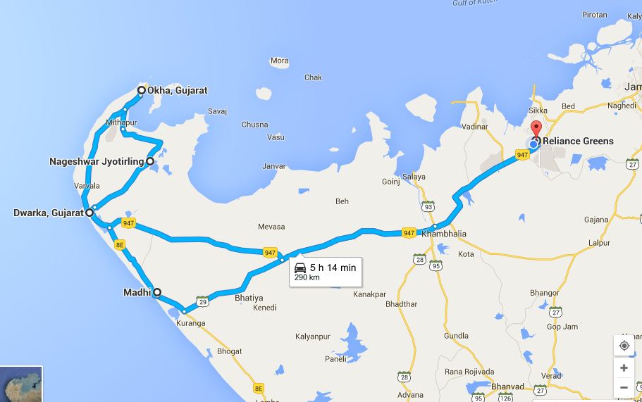
The Kutch Tour map: ~1500 Kms done over 4 days. Red circles/marks showing places of Interest.

The Ooommph factor:

  • Vast (Infinite) salty & muddy plains, with patches of thorny shrub in name of greenery.
  • Trees are hard to find in 100 of KMs of drive and thus natural shade is missing.
  • Fittingly called White desert. White because of precipitated salt.
  • Rann Utsav, held in months of November to Feb, is a colorful cultural extravagance.
  • Food, Cloth, Mud houses for stay & remains of 2000 yrs old Harappa civilization.
  • Many Bollywood movies have been shot in this region. Lagaan, Refugee, Hum Dil de Chuke Sanam, to name few.
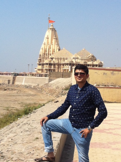
Places to visit:

Mandvi: A sleepy beach town on coast, which can be skipped, if on a short tour (< 3 days)

  • Mandvi beach: Bathing facility, horse rides, Camel ride, Amateur water sports.
  • Vijay Vilas palace: Palace of erst while king, now turned into small museum. Lagaan movie was shot here. Entry fee, parking fee etc. applicable
  • Godhara Ambedham: Neat & Clean temple with free lunch.
  • Shyamji verma Memorial: An European styled house, in middle of no-where, belonging to a freedom fighter.
  • Vijay Vilas Palace

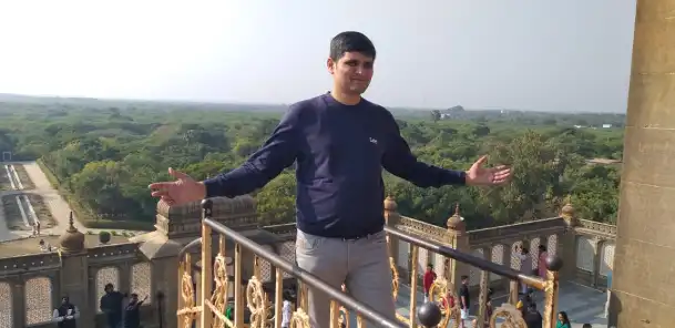
    Vijay Vilas Palace, where block buster Bollywood movie Lagaan was Shot

Narayan Sarovar & Lakhpat:

  • Again, because of distance, these two places should be done, only if tour is >3 days in this area.
  • ~150 kms from Bhuj/Mandavi. Narayan Sarovar is the extreme most West point of India.
  • Narayan Sarovar is a temple village right on the coast. Has beautiful sight of coast. Got basic facilities of parking, toilets & snacking.
  • Lakhpat is a huge (village) fort on shores of sea, which gets dried in winter leaving vast stretches of white sand (i.e. salty sand). Got some excellent view of white desert. For us, the excitement & wow! Factor was more, as we saw White desert for the first time.
Narayan Sarovar

Pic @ Narayan Sarovar

Lakhpat fort

Lakhpat fort – White desert in background – Refugee Movie was shot here

Mata No Madh:

  • Temple town dedicated to Ashapura Mata.
  • Neat & clean temple premises and the town has got basic facility of food, lodging etc.
Mata No Madh

Mata No Madh- Ashapura Mata Temple

Rann Utsav:

  • A 2 days must stay tent city town which gets raised in Winter months, welcoming lakhs of domestic & international visitors.
  • A huge shopping area, local folk dance & performances, camel rides, great view point, hot air balloon ride, variety of food.
  • Main attraction is “Salt molecule” shaped structure, to view vast white sand desert or as they say “WHITE RANN”. It is the best point to see Sun set, moon rise & moon light lighting up the white sand.
  • One can also opt from hundreds of mud houses to stay, around the main Rann Utsav.
The hut

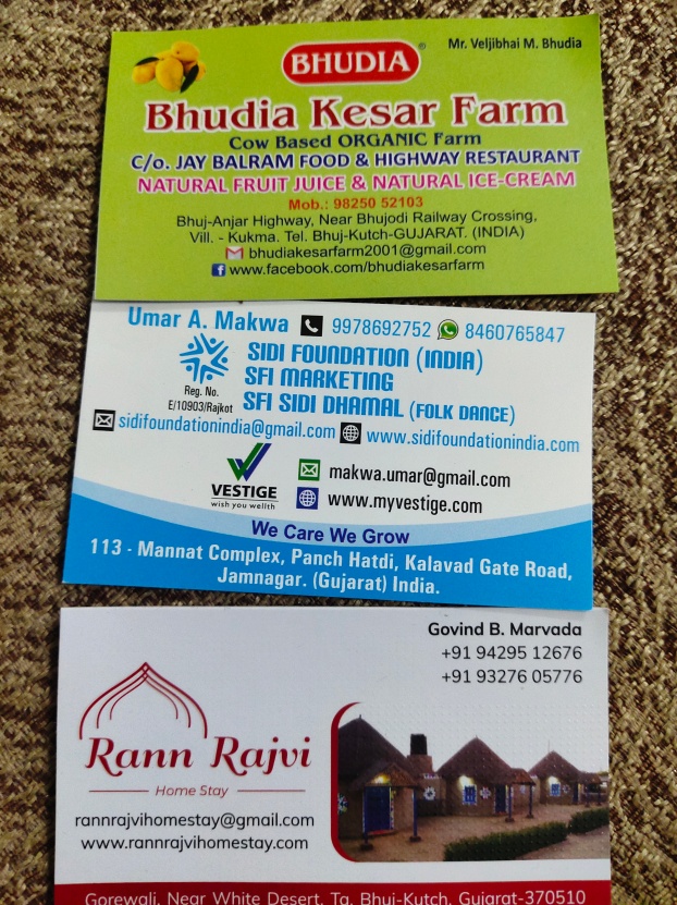
Rann Rajvi- Hut home stay in Kutch/ Rann of Kutch / White desert
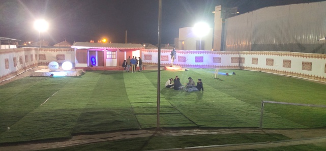
Rann Utsav

In Rann Utsav

India Bridge & Vighakot fort (India-Pakistan Border):

  • Till India Bridge, one can drive. But to go beyond, permit is needed which is available only in Army base of Bhuj.
  • Drive beyond India Bridge is through middle of vast salty plains, with not a single shade of tree available. The only human being available after this, are rough n tough Indian army men. Road is very narrow & only one vehicle can pass at a time.
  • Also, mobiles, cameras etc. have to be submitted to army men at India bridge.
  • Army men do give a small brief at Vighakot & Pakistan posts are clearly visible from here.


Kalo Dungar:

  • The place is highest in Kutch and thus offer stunning view of Kutch & white desert.
  • Famous as Sun set & sun rise viewpoint.

Tropic of Cancer:

  • Tropic of cancer run across the highway drive from Rann of Kutch to Bhuj.
  • A signboard (pin available in google map) shows same.

Bhuj:

  • Biggest city of Kutch and is well connected by Train from various cities of India
  • It has got an airport, but only flight is to/fro Mumbai.
  • Main attractions: Aina Mahal & Prag Mahal (seemed like Pilot version of CST terminus of Mumbai), Bhujia fort atop hills, Vande Mataram Museum, Swami Narayan temple, Lake.
  • If in Bhuj: Prag Mahal, Bhujia fort & Vande Mataram are must visit & can be covered in 1 day. Others can be done, if time permits.
  • In n around Vande Mataram Museum, is handi-craft village, from where at least memento can be bought for Kutch memory.

Drive from Bachau to Morbi:

  • This road is what connects Kutch with rest of country. A very picturesque road, but equally busy. It has got good dhabas/restaurants like Honest etc.
  • Sea has entered land here, thus a small parcel has it all: roads, rail, power transmission tower, wind mills.

Others:

  • Kandla, Gandhidham are other two big port cities in the region.
  • Most truck traffic on highway is because of these two ports.
  • Adani port is now largest port of India, in terms of tonnage of cargo handling.

Other: Dholavira:

  • It is the other (east) side of Kutch and would be need a day on its own.
  • It used to be a port city when Rann was actual Sea during Harappa civilization.
  • The archelogy remains, and museum is reminder of same.
  • It is supposed to give same feeling as Rann of Kutch, albeit with less crowd & extravagance.


Beware of:

  • Weather: It can get very hot in summer. Donot attempt to venture into plains without proper help/guidance. Nights in winter can go very cold (feels like temp of 5-10 degC kind of range).
  • Vehicle malfunction: Certain roads are in No man’s land. Vehicle technical help will be very limited in certain highways/roads. Better be prepared/trained. We had the experience of puncture in middle of white desert. Kindly driver had the tools & skills to amend same.
  • Special dietary requirements: After & beyond Bhuj, very limited options of food will be available. Better be prepared, if you are very choosy.
  • Donot dis-obey army rules. This is a border area

Our Trip:

  • 5 families: 17 homo sapiens including the children
  • Mode of transport: Force tempo traveler
  • Total Distance covered: ~1500 Kms
  • 23:30 hrs of 10th Jan to 22:00 hrs of 14th Jan 2020 (~4 days)
  • Day 1: Reliance green -> Dhrol -> Morbi -> Bhachau -> Bhuj -> Mandavi (Sight-seeing)
  • Day 2: Mandavi -> Narayan Sarovar -> Lakhpat fort -> Mata No Madh -> Gorewali (Rann Utsav)
  • Day 3: Rann Utsav -> Khavda -> India Bridge -> Vighakot (India _pakistan border) -> India Bridge -> Khavda -> Rann Utsav
  • Day 4: Rann Utsav -> Tropic of cancer point -> Bhuj (sight-seeing) -> Bhachau -> Morbi -> Dhrol -> Home
  • Cost: Rs ~25000-30000 per family
  • Stay in Mandavi @ Radhe Motel. A decent hotel, providing neat toilets & bedsheets.
  • Stay in Rann: @ Rajvi home stays. Very good huts like neat bedsheets & toilet, providing home cooked kutcha food. Has got facility of bon-fire, music etc.


kutch contacts

1) Stop for good and natural ice cream & juices (2) Our African descendant driver, who does good African dance (2) Hut stays in Rann/Kutch

Bus

Troop in Traveler


Day trip to Somnath-7th Feb-2016 February 20, 2016

Route: Reliance Green –> Khambaliya -> Shingda -> PORBANDAR -> MADHAVPUR ->Mangrol ->Chorvad -> SOMNATH -> JUNAGAD -> Kalavad -> Reliance green

Total Distance: ~500 Kms

Time: 6:30 AM to 8:00PM

Mode of transport: Car (Maruti Swift)

Places of interest:

a) Porbandar: Birthplace of greatest personality of modern times, Mahatma Gandhiji

b) Somnath: One of the 12 Jyotirling temple of Lord Shiva, which have risen from ashes, not once, not twice, but more than 5 times.

c) Beautiful beach of Madhavpur

d) City of Junagad, famous for Girnar temple & ancient buildings, standing testimony of it’s glorious history, it had.

e) The region has given people like Dhirubhai Ambani, Mahatma Gandhi are proof of it’s glorious history. Seeing architecture of villages & towns, one could easily make-out, the rich times the region enjoyed, because of maritime trade & commerce & it’s entrepreneurial  people.

Somnath

We started from Reliance Greens around 6:30 AM and with no stops, reached Porbander by 8:15 AM. Luckily, the Gandhiji’s ancestral home & birth place, had opened. With no traffic, we could criss-cross thin strip roads pretty fast. From the roads & architecture of houses, shops, one could easily make out the town being many many centuries old. Gandhiji’s house is really a big one with some 22 odd rooms & a courtyard, which could beat any average playground size, Indians play cricket in. The house was purchased apparently by Gandhiji great grandfather in 1777 (actual copy of the deal is there in the photo gallery) & seem to be in what would be a posh locality of that time, as it is looked kind of a gated community. The house is now a museum with well maintained photo gallery, celebrating Gandhiji’s life & his contribution to India’s (& Pakistan’s) independence. Besides being Gandhiji’s birthplace, Porbander is also famous of its port, salt works & last but not least, “Nirma factory”, the detergent with fame of “sabki pasand Nirma”. We visited Sudama temple nearby, savored on breakfast of fafra jalebi, puri bhaji, patra and ultra-sweet gujju tea. By 9:00 AM, we were on our way to Somnath, driving parallel to coast along NH-8E.

We had to take de-tour before Madhavpur, because a section of a brand new bridge over a river, had collapsed (obviously shoddy work by contractor). Soon, we reached beautiful & secluded beach of Madhavpur. Again, with few Indians visiting the beach, it was very neat & clean.

After loffering around 20 mins in beach, we started for Somnath. Now, the countryside resembled like my native place (Coastal Odisha), plain stretches with lots of coconut trees. We zipped through Mangrol, Chorvad. Both towns, seemed to be centuries old & later is the birthplace of India’s no.1 entrepreneur , Dhirubhai Ambani.

By 11:45, we were in Somnath. The final section of ~20 Kms, is section of NH 8D (Somnath-Junagad) & is a super 4 lane toll highway. I could make out super infrastructure development that has happened. The walkways, parking, roads etc. were all brand new.  Unexpectedly, the place was relatively neat & clean & well maintained. Somnath is one of the 12 Jyotirling’s of Lord Shiva & thus has been an important pilgrimage for Hindus, for time immemorial.

Somnath, the magnificent  & ancient temple, is a shining example of superiority of perseverance over destruction. The temple, has been “man” destroyed at least 6 times in past 1000 years & each time, it has risen like “phoenix” from ashes. Personally, I feel, this temple is an example of what Hinduism is. It’s about believe in your faith, what-so-ever, believe in peace and “mind your own business” attitude. Examples like Somnath proves that Hinduism is not exactly a religion..it is a way of living. Every time, I read history of temples like Somnath, Konark, only one question come to my mind :”How can one think also about destroying such a beauty?”, but fact is: man has not only thought but destroyed as well these places, not once but more than that.

Coming back, with such history of destruction, obviously the security of Somnath is very tight. Belt, mobile, bags etc. are not allowed and free locker facilities are available. Ample parking spaces, shoe stands, toilets, eateries, ATM & all other basic amenities are available, all near the temple. Temple has three aarti timings (morning, afternoon & evening). Luckily, we reached at 12:00 and were blessed to see the aarti. Weather was perfect, crowd was thin, temple was neat & clean & aarti darshan, all made it very a very memorable & blessed visit.

Temple also hosts an “light & sound” show in evening, in an open air amphitheater, with one end being sea and other Temple. Elaborate arrangements of seating are made in & around temple, to enjoy temple, sea & sun-set. There’s also an Arrow-pillar, which signifies that there is no land mass in the direction of arrow (& actually the next land mass that comes in the direction of arrow is, Antartica). There are few other small temples & a gallery showing 12 Jyotirling’s of Lord Shiva. What was really missing, was the exhibition to celebrate (& mourn as well) the history of the temple. I was expecting it to be there & to my utter dis-appointment, there was nothing. Only thing, I could see was a (poor) photo gallery, with excavation photos, which was done in 1940-60s. Dear govt, this photo gallery is not a museum, please create an exclusive one, the temple’s glorious history deserves one.

IMG_4933IMG_4934IMG_4945IMG_4923IMG_4946

After enjoying temple & sea, and clicking some photos for fb/blog, we filled out stomach in a near by Punjabi restaurant. By 2:30PM, we started by first leg of return journey. This time we took NH-8D, newly completed 4 lane toll highway. The road was super, we reached Junagad by 3:30PM.

Junagad was a princely state before Independence and was of the two kingdoms (other being Hyderabad), whose kings wanted to be part of Pakistan. I am sure, now they would be glad, that they are not part of Pakistan. Junagad is famous for Girnar temple, a hill top temple, having a following among Hindus & Muslims of the region & across the country. The temple is accessible only by foot steps and many people also do parikrama (walk along the circumference of the hill), which measures something like ~40 kms. Junagad, also is the launch pad to visit world famous & only Asiatic Lion sanctuary, “Gir forest”, some 100 kms away.

We did neither of above, because of lack of time. Rather we took a guided tour (& guide was drunk, surprisingly in a dry state) of Junagad palace, which turn out to be pretty boring to me & my friend as well. If not Gir forest, at least visit zoo. So we visited Junagad zoo, again turned out to be very boring. By 6:00 PM, we were done with all this and decided to return. On way out of Junagad, we saw number of ancient buildings, which were now converted to schools, colleges, hospitals, govt offices and grand mosques, all telling it’s glorious history of being an independent state.

We took highway 927D, a 2 lane smooth road & via Kalvad reached Reliance Greens by 8:00PM. A day-off well spent with darshan of Gandhiji’s birthplace & Somnath temple.

Wish readers, a happy, safe & litter free travelling.

Photo of the trip:


Bike trip to Dwarka-31st Jan-2016, Fafra-Jalebi route February 14, 2016

Route: Reliance greens (Jamnagar) -> Khambaliya -> Madhi -> Dwarka -> Nageswar -> Mithapur -> Okha -> Dwarka -> Highway 947 (Charkala)-> Khambaliya -> Reliance green

Bike: Honda Unicorn

Trip meter -> ~300 kms

Time: 7:15 Am to 5:30 PM

route

Places of interest:

  1. Beautiful beach of Madhi (also called Bechtel beach))
  2. Teerth sthal (holy city) of Dwarka
  3. Nageswar (supposedly a Jyotirling) & Gopi kund.
  4. Okha (one of the western most tip of India) & last/1st railway station
  5. Expansive salt lakes throughout the journey. Most amazing one seemed to be “Charkala” salt works on highway 947
  6. Island of Beyt Dwarka
  7. The region is heaven for Ornithologist, with some unique birds, which I have not seen in other parts of India.
  8. Debate over lost city of “Dwarka” also makes it interesting place for archaeologist & historians.
  9. Good quality roads, little traffic, wind mills, occasional salt lakes, coastline etc. on a winter day, is a perfect recipe of a pleasant drive.

Cautions:

  1. Fuel stations, both for vehicle & stomach are very few.
  2. Choosy foody people may suffer. In whole route, Dwarka is only place with certain options. Otherwise, it’s only “khakra & jalebi”.

It was my, what 20-odd trip to Jamnagar & I had hardly explored the region. This time I was on 2 weeks trip & so decided, will see all the places around. I borrowed Honda Unicorn from my friend (thanks Prakash R) & set on to Dwarka on a perfect wintery Sunday morning, around 7AM, alone. The 4 lane highway near Reliance mega refinery, gives way to 2 lane highway immediately after Essar refinery. But still quality of drive remains more or less same, as road was good & traffic, less. I filled bike tank with petrol & my tank with breakfast of fafra & jalebi. The NH-29 to Karunga is a bit boring drive, with dry arid region & scrub vegetation, with occasional wind mills.But right turn towards Dwarka near Karunga & suddenly view changes. Now, I was on NH 8E/6, which connects Dwarka & Porbander (birthplace of Mahatma Gandhiji). Few miles away from the right turn in Madhi beach. On one side of the road is beach & other side, huge salt lake, which makes a perfect place to stop & capture some photographs for memory & facebook. The beach also got a small, turtle egg laying place. Good part is, since there is no eating place, it looks like hardly any Indian visit here & so the place is very neat & clean. Interestingly, it is tagged as Bechtel beach in google map, which shows the no. of visitors Reliance gives to this place (Bechtel is Oil & gas DEC behemoth & is DEC contractor for Reliance Jamnagar refineries).The few benches on the beach (this is best thing I like in Gujarat…they have benches for seating, everywhere) makes a perfect chilaxing point. Although I wanted to stay for some more time, but the thought of reaching Dwarka before temple closing time, I started from Madhi beach with a resolution that, I will come back again here for a night camping. Madhi to Dwarka is ~25 kms highway running parallel to the coast. Few pics of beautiful Madhi beach:

So by 9:30 AM, I was in Dwaarkadheesh temple. After getting the darshan of lord around 10:15 AM (to my surprise, it was not crowded at all), I started exploring the place around the temple. Mobile phones, bags etc are not allowed inside the temple. The walkway to temple, seems to have been developed by Ambani family. The tiled walkway has got some 100 odd paintings depicting life of Lord Shree Krishna. Some decent infrastructure is provided around the temple, but as usual like any other Indian religious place, the place is bit dirty. There are again benches in Promenade behind the temple, a perfect place to see sunset. There are many more ancient temples, a hanging bridge over the (shallow) Gomti river, as it flows into the sea. But I was not that interested. So, after a stay of ~1hr, I started my drive towards Nageshwar. Here are few pics of Dwarkadheesh temple.

BTW, I did my research on Old Dwarka city (after returning from journey). I am convinced, that a great city (not the way it is not shown in some mythological serials. The serial is an artist depiction.) did exist 10,000 yrs ago & got swallowed by sea. It’s pity that our own govt has stopped exploration of our great history.

Back to travelogue, I started by 11:00 towards Nageswar temple, ~18 KMs ride from Dwarka. Some people, across India, believe it is a Jyotirling, one of 12 holiest places of lord Shiv. Nevertheless, I visited more as a tourist than a religious person. Luckily, even this place was not crowded and within few mins, I got darshan of Lord shiv’s jyotirling (It was inside a glass enclosure). The temple also had a big statue of lord Shiva. After savouring on coconut water, I started towards Gopi kund, where supposedly Lord Krishna took bath along with Gopis. Against my expectation, it was a very small (Indian) pond.

From Gopi Kund, I started towards Okha, with a resolution to reach one of the westernmost tip of India. The road seemed to be polluted with salt & also could be seen was Tata chemical factory of Mithapur. On way, also comes Arambhada, which it seems has a ship breaking & recyling industry.

Finally I reached Okha, the place I had heard all these years in train name “Puri-Okha express”. As I was in Okha railway station, I realized I was like ~2000 kms away from my hometown & ~50 hrs away, if I travel in  Okha-Puri express. Okha, is the western most railway station on Broad gauge line & is connected by rest of India with number of long distance pilgrimage express.Both road & rail line terminates in Okha port, which also is gateway to island of “Beyt Dwarka”. Because of lack of time, I decided not to visit Beyt Dwarka. After few clicks of Western most tip of India, I started my return journey.


On return journey, I had my lunch in Dwarka and took highway 947 via Charkala , to reach Khambaliya. From maps, I always knew that this road is far from coast, but was surprised the moment I reached Charkala salt works. The salt lakes were like sea. There was no end to water, as far as I can see. Later, I figured out, actually they had channeled sea inside landmass, resulting in massive salt lakes. Those were last clicks of my day long tour & I reached Reliance guesthouse by 5:30PM.

It was good day long bike trip after almost a year. Now out of 4 teerth dham, I have visited 3 , with only “North Dham” Badrinath remaining. Interestingly, I have done all 3 in bike, hope to do 4th one in bike as well. JAI SHREE DWARKADHEESH. JAI SHREE KRISHNA.